Remote sensing tools + horizontal directional drilling =
- High resolution data from hard to access areas!
- Structures, utility lines, streams, and sensitive environments not an obstacle
- Get your data in real-time!
- No delays due to sample collection and laboratory analysis
- Subsurface assessments without causing interruptions!
- Keeping the client’s infrastructure undisturbed and their site operations unhindered
How many times have you had to compromise on the placement of your wells or borings due to site-specific physical or operational obstructions? When faced with site constraints that made assessing soil contamination at a MGP facility a challenge, one of our consultant partners with a knack for problem solving turned to optical fluorescence screening sensors as the best tool for the job. The remote sensing tools were able to capture high-resolution data from contaminated areas directly underneath on-site utilities, stream beds, and buildings containing critical infrastructure that would have been inaccessible through traditional means. Best of all, they were able to do so without ever needing to collect a single sample, interrupt site operations, or compromise on what they could deliver for their client their due to site constraints.
Directional Technologies is fortunate to work with many consultants who are always looking for better ways to overcome the challenges that come with addressing a wide range of remediation projects.
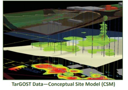
Working in close coordination with our resourceful consultant partner on a recent project, we were able to utilize TarGOST (Tar-specific Green Optical Screening Tool) sensing technology to identify NAPL distribution in real-time, allowing for a drastic reduction in time spent identifying impacted areas and achieving a higher resolution conceptual site model than would be available through other alternatives. This project pioneers a new tool for the environmental industry to realize the benefits of remote sensing to its fullest extent.
Using sensing technology which functions by taking high density fluorescence measurements as a sensor is advanced along a borehole, we were able to rapidly assess NAPL concentrations in the field at the site of a former MGP facility impacted by coal tar contamination. TarGOST creator Dakota Technologies was an integral part of the process, providing real-time analysis of the field data in order to log NAPL presence versus depth. Thanks to the near-instantaneous feedback from the TarGOST, valuable information on contaminant distribution was able to be gathered without the need for sample collection and time-consuming laboratory analysis. Together, we were able to utilize the field data to adjust planned bore hole locations on the fly in order to more precisely bound the zones of NAPL contamination.
The project location included multiple structures, a stream, and various underground utilities. It was determined that deploying the TarGOST along a horizontal bore path would provide the greatest benefit to the assessment activities by enabling more in-depth data regarding the locations of contaminated zones relative to the various site features while minimizing disruptions to the site. Directional Technologies was able to use their extensive experience in horizontal directional drilling techniques for environmental applications to design horizontal borehole layouts that would yield high resolution data from the TarGOST while avoiding disruption to the site buildings and other sensitive areas. Using horizontal bore paths, we were able to identify contamination beneath utilities and structures which may not have been apparent from TarGOST data collected from the nearest available location for a vertical bore path.
The data collected in the field was used to produce a 3-dimensional conceptual site model which will allow for improved targeting of contaminated zones during the remediation process. Utilizing horizontal directional drilling and fluorescence sensing technology we were able to help our client develop a refined remedial action plan while reducing the time it took to complete assessment activities.
Have you considered how remote sensing tools under buildings could help you complete assessment activities sooner and develop better conceptual site models? Call our horizontal well experts at 877-788-4479 or email us at drilling@directionaltech.com to have your project assessed.